Why heavier rainstorms don’t always mean more water in the Mountain West
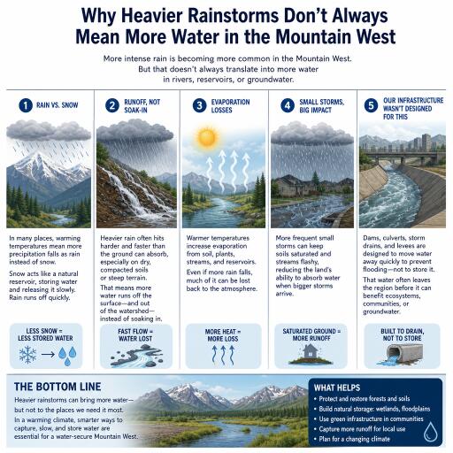
Across the West, rain is increasingly arriving as short, powerful bursts separated by longer dry spells. It might sound like a recipe for replenishing soils, streams, and reservoirs. But emerging research suggests the opposite: when storms hit harder and less often, landscapes can end up holding less water over time.
Downpours, dry gaps, and a thirsty landscape
Decades of weather and land-surface observations point to a clear pattern. As rainfall bunches into fewer, more intense events, less of it seeps into the ground and more of it lingers on the surface. That water is then more likely to rush off as runoff or evaporate quickly once skies clear.
The reason is simple physics. Soils take time to absorb moisture. When rain arrives gently and steadily, it can infiltrate, recharge groundwater, and sustain plants for weeks. But when it falls like a deluge, the ground’s capacity to drink is quickly overwhelmed. Water ponds, flows downslope, and often bypasses the natural storage offered by soil and shallow aquifers. In arid and semi-arid terrain like much of the Mountain West, hard-baked soils and sparse vegetation can make this effect even stronger, further limiting infiltration during big bursts.
Western watersheds face a double bind
The Mountain West is already managing a precarious water budget. Warmer winters have nudged precipitation from snow toward rain at certain elevations, shrinking the slow-release reservoir that snowpack provides. When that rain increasingly falls as cloudbursts, it amplifies the region’s boom-and-bust pattern: more flash flooding and sediment-laden flows in the short term, followed by quicker drying once storms pass.
For communities and water managers, that means planning for two extremes at once. Heavier storms can strain culverts, erode burn scars, and trigger debris flows. Yet despite the drama of a big storm day, the longer-term soil and ecosystem moisture—a key buffer against drought—may not improve, and can even decline if the gaps between storms stretch longer.
Wildfire risk doesn’t disappear with big rains
Moisture delivered in a downpour doesn’t linger the way slow, steady precipitation does. Vegetation and surface soils can dry swiftly in subsequent warm, windy weather. In some cases, heavy rain can even spur a quick pulse of plant growth that becomes fine, flammable fuel later in the season if follow-up rains don’t materialize. The result: landscapes can still be primed to burn, even after impressively wet episodes earlier in the year.
It’s the pattern, not any single storm
A crucial nuance: no one is saying every major storm worsens drought. Instead, the long-term shift toward fewer, heavier events tends to reduce how efficiently landscapes store water. That matters for agriculture, forests, and cities alike. Fields and rangelands rely on consistent soil moisture to support crops and forage. Forests depend on steady recharge to maintain tree health and resist pests. Urban systems must capture and store water when it arrives or risk watching it run off unused.
Adapting for a “flood-and-drought” future
The tools to cope with this new normal are not mysterious, but they require rethinking priorities and timelines. Strategies that slow water down, spread it out, and store it closer to where it falls can help convert quick pulses into lasting reserves.
- Flood-smart infrastructure: Expand and modernize stormwater systems to handle cloudbursts while protecting neighborhoods and restoring floodplains that naturally absorb and store water.
- Managed aquifer recharge: Use basins, infiltration galleries, and seasonal spreading fields to capture stormwater and deliberately push it underground when soils can accept it.
- Soil health on working lands: Boost organic matter, reduce compaction, and use cover crops where possible to increase infiltration and water-holding capacity.
- Forest and watershed restoration: Thin overgrown stands, restore riparian corridors, and reduce fuels to improve infiltration, stabilize soils, and moderate post-storm erosion.
- Flexible operations: Adjust reservoir rules and urban capture programs to seize big, brief inflows without compromising safety.
What to watch next
Scientists continue to refine how shifting storm patterns interact with temperature, vegetation, soils, and terrain. Key questions include how different soil types in the Mountain West respond to extreme rainfall, which land management practices most effectively convert intense storms into groundwater recharge, and how changing precipitation shapes crop yields and wildfire seasons across elevation bands.
The bottom line: bigger storms are not a simple fix for a drier West. In a climate skewed toward intensity, resilience will depend on how well we turn sudden surges into slow sips—keeping water in the ground, on the land, and available for ecosystems and communities long after the skies clear.


Leave a Reply