
-
 Marcus Rivero
 - Eco-Tech Innovations
- July 19, 2026
Ethiopia marks 60 years of wildlife conservation with a new vision for people and nature
Ethiopia's conservation milestone Ethiopia is reaching a landmark moment in environmental protection as the country…
-
 Ava Bloom
 - Biodiversity
- July 13, 2026
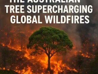
How Eucalyptus Plantations Are Intensifying Wildfire Risk Around the World
The Australian Tree Reshaping Fire Risk Around the World As another season of extreme heat…
-
Marcus Rivero
- Eco-Tech Innovations
- June 21, 2026
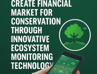
Landseed Builds Ecosystem Monitoring System to Turn Conservation Into Financial Value
Landseed Aims to Create Financial Market for Conservation through Innovative Ecosystem Monitoring Technology - SSBCrack…
-
 Ethan Wilder
 - Climate Change
- May 20, 2026
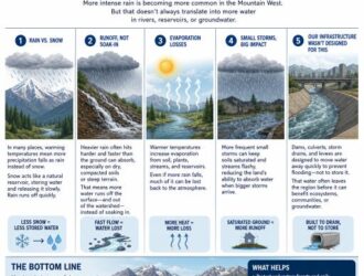
Shifting Storm Patterns: Why Heavier Rainfall May Not Boost Water Reserves in the Mountain West
Why heavier rainstorms don't always mean more water in the Mountain West Across the West,…

-
Marcus Rivero
- Eco-Tech Innovations
- April 26, 2026
Third Synchronized Census of Nilgiri Tahr: A Collaborative Step towards Conservation in Tamil Nadu and Kerala
TN rolls out 3rd Synchronized survey of Nilgiri Tahr Tamil Nadu has launched the third…

-
Marcus Rivero
- Eco-Tech Innovations
- March 29, 2026
The Elusive Arabian Sand Cat: Master of the Desert’s Shadows
The elusive Arabian sand cat When the heat lifts off Oman’s dunes and the horizon…

-
Ethan Wilder
- Climate Change
- March 18, 2026
Mapping Tsunami Aftermath: How Satellite Imagery Reveals Hidden Health Impacts
Satellite Imagery Links Tsunami Impact to Health When a tsunami tears across a coastline, the…

-
Ethan Wilder
- Climate Change
- February 24, 2026
Grazing Under Threat: How Climate Change Could Render Half of Global Pastures Unviable by 2100
Climate Change Threatens Global Grazing Systems; Up to 50% Grazing Land May Become Unviable by…
-
Marcus Rivero
- Eco-Tech Innovations
- December 21, 2025
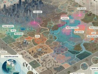
Analyzing Ecosystem Service Trade-offs in Beijing: A Guide for Sustainable Urban Planning and Management
Spatial heterogeneity and driving factors of ecosystem service trade-offs in Beijing's ecological conservation area: Insights…

-
Ethan Wilder
- Climate Change
- December 8, 2025
Understanding UAE’s Wetter Week: Humidity, Fog, and Visibility Challenges
Humidity rises, visibility falls: What's driving the UAE's weather this week A humid, moisture-laden air…


