AI Evaluation Reveals Seoul and Incheon as ‘High-risk’ for Flooding
As climate change continues to drive unpredictable heavy rainfall patterns, a new study highlights the potential vulnerability of major urban centers such as Seoul and Incheon to significant flooding events.
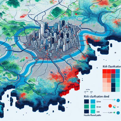
On May 28, a research initiative led by Pohang University of Science and Technology unveiled a comprehensive “flood risk map” for the nation. This was achieved through the application of artificial intelligence (AI) to scrutinize flood damage data spanning the last two decades, as recorded by the Ministry of the Interior and Safety. Traditionally, flood risk prediction has been grounded in the analytic hierarchy process (AHP), a method that heavily leans on subjective expert assessments. While insightful, it often lacks the efficiency and numerical transparency offered by emerging technologies.
The research team at POSTECH innovatively employed AI to focus on four critical elements that determine flood risk: hazard (intensity of rainfall), exposure (at-risk populations and facilities), vulnerability (potential for damage), and response capacity (capability to manage the threat). Among several AI applications evaluated, “XGBoost” and “Random Forest” algorithms emerged as frontrunners, boasting a predictive accuracy exceeding 77%. Each model, however, focused on diverse risk factors. XGBoost highlights the “ratio of impervious surfaces” as a crucial risk element, indicating areas where rainwater is unable to infiltrate the ground. Conversely, Random Forest places emphasis on “river area” as the principal risk factor. Despite these variations, both models consistently identify Seoul, Incheon, and other prominent metropolitan regions as “high-risk zones” for flooding. This classification underscores these cities’ heightened vulnerability due to dense populations, extensive concrete surfaces, and closely situated buildings and infrastructure adjacent to rivers.
A standout achievement of this research is the integration of an objective numerical assessment of “prediction uncertainty” regarding flood risks. Areas that multiple AI models identify as high-risk can be prioritized for urgent disaster management efforts. Meanwhile, regions where model predictions diverge signal the need for further analysis. This strategic approach aids in crafting effective, cost-efficient flood mitigation plans under tight financial constraints.
The research team underscores the importance of addressing identified risk factors such as ‘impervious surface ratio’ and ‘river area.’ Suggestions for reducing flood damage include adopting sustainable urban development practices that prioritize green spaces for natural rainwater absorption and limiting development in proximity to riverbanks.
This groundbreaking research has earned a place in the esteemed “Journal of Environmental Management,” which is renowned for its contributions to environmental science.


Leave a Reply