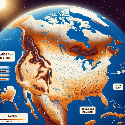
Alaska included in large ‘Mega-drying region’ in new research
Alaska now falls within a vast belt of land experiencing rapid drying, according to new analyses of Earth’s water storage from space. The findings point to a sweeping pattern of declining water availability extending across parts of North America, Latin America, Europe, Africa, and Asia, with serious implications for ecosystems, infrastructure, and communities.
A growing footprint of dryness
Researchers using two decades of observations from NASA’s GRACE satellites report that “mega-drying regions” are expanding each year by an area roughly twice the size of California. These evolving zones include broad swaths of Alaska, Canada, and the western United States, along with parts of Mexico, Central and South America, Europe, northern Africa, and central to southeast Asia. The scale and pace of change indicate that water, a primary messenger of climate disruption, is delivering increasingly urgent warnings at a neighborhood level.
How satellites weigh the planet’s water
GRACE, first launched in 2002, measures tiny variations in Earth’s gravity caused by shifts in mass at the surface—ice sheets thinning, glaciers retreating, aquifers draining, soils drying, or lakes and rivers shrinking. As the satellites pass over regions losing water, the gravitational tug weakens slightly, subtly altering their orbit. Summed over thousands of passes, those deviations reveal how much water has been lost or gained across continents. The result is a global ledger of “terrestrial water storage” (TWS), the sum of water held in snow and ice, surface waters, soils, and deep-rooted vegetation.
Alaska’s paradox: wetter skies, drier ground
Alaska’s inclusion in the drying belt may seem counterintuitive because average precipitation has ticked upward in many areas—on the order of 5% to 10% over recent decades. But warmer temperatures accelerate evaporation from soils and transpiration from plants, and they lengthen the snow-free season. The outcome is a paradox: even as total rainfall increases, landscapes can dry out faster between storms, intensifying drought risk.
Recent years in Alaska have showcased this volatility. The state has swung from severe, short-lived drought to record-breaking wet conditions in the same calendar year. Such whiplash is becoming a hallmark of a warming climate: longer dry spells punctuated by heavier downpours, straining streams, wetlands, and the people who depend on them.
Where drying is most pronounced
- High-latitude regions, including interior and western Alaska, where warming is fastest
- Western North America, affected by shrinking snowpacks and overdrawn groundwater
- Parts of Mexico and Central/South America facing multi-year precipitation deficits
- Europe and northern Africa, where heat waves and shifting storm tracks magnify water stress
- Central and southeast Asia, where changing monsoon patterns and demand pressures collide
What the data do—and don’t—say yet
State experts emphasize that Alaska’s hydrologic system is complex and variable, influenced by both rising precipitation and glacier retreat. To sharpen conclusions, they point to the need for expanded water-level monitoring, deeper aquifer studies, and coordinated observation of short- and long-term trends across watersheds. Hydrologists also caution that while two decades of satellite records capture powerful signals, 30 or more years are typically needed to fully separate long-term trends from natural variability.
Communities caught between water abundance and access
Alaska as a whole holds vast freshwater resources, but their location and timing do not always match where people live or when they need water most. Drying landscapes can lower streamflows, stress subsistence fisheries, and increase wildfire risk. Meanwhile, rain arriving in fewer, more intense bursts can overwhelm drainage systems, accelerate erosion, and threaten infrastructure—from rural roads to urban neighborhoods built on thawing permafrost.
All of this complicates water management: communities may confront both scarcity and flood risk over the course of a single season. In rural regions, hauling water and maintaining storage can become harder during prolonged dry spells. In urban areas, the challenge is balancing conservation with investments in stormwater control, green infrastructure, and resilient supply networks.
Adapting to a new water reality
The expanding footprint of dryness underscores the urgency of planning for a climate where historical averages offer less guidance. Practical steps include strengthening groundwater monitoring, protecting headwater wetlands, restoring rivers and floodplains to store water naturally, upgrading culverts and storm drains for heavier rain, and improving water use efficiency in homes and industry. For Alaska, where cold-region hydrology is rapidly evolving, community-driven adaptation—especially in remote areas—will be central to safeguarding water security.
Even as the science advances, one conclusion is clear: adaptation must move in tandem with mitigation. Cutting greenhouse gas emissions can slow the expansion of mega-drying regions. At the same time, designing for deeper droughts and sharper deluges will determine how well communities weather the changes already underway.


Leave a Reply