Enhancing Groundwater in Western Ghats via Runoff Harvesting
High on India’s western spine, the Western Ghats funnel monsoon rains through steep slopes, dense forests, and fragmented farmlands. Yet much of this seasonal bounty rushes away as surface runoff, eroding soils and leaving dry-season wells to run low. A new wave of research and field trials points to a pragmatic fix: capture runoff where it forms, slow it down, and guide it into the subsurface—using geospatial intelligence to put every intervention in precisely the right spot.
Turning monsoon runoff into recharge
Runoff is often treated as a problem—fuel for flash floods and sediment loss. In the Ghats’ rugged terrain, this is amplified by land-use change and more erratic rainfall. Capturing that flow before it concentrates can turn a liability into a lifeline. Site-specific runoff harvesting captures short, intense pulses and converts them into groundwater recharge, strengthening baseflows in streams, stabilizing wells through the lean months, and reducing downstream flood peaks. The key is to do it surgically—small structures, tailored to local soils, slopes, and aquifer conditions—so that ecological integrity is maintained.
Mapping the best spots with geospatial intelligence
Modern mapping tools are reshaping how water managers pick sites. High-resolution elevation models identify micro-catchments and natural depressions; satellite imagery maps land cover, canopy density, and bare-soil patches; rainfall and storm-intensity grids highlight hotspots of rapid runoff; and geological data reveal fractures and lineaments where percolation is most effective. By layering these inputs in a GIS and applying multi-criteria analysis—balancing recharge potential with erosion risk, landslide susceptibility, and habitat value—teams can pinpoint zones where small interventions have outsized benefits with minimal ecological disturbance.
Crucially, this approach goes beyond reactive flood control. It anticipates where rain will exceed infiltration, places structures upslope to spread and sink water, and uses local evidence to avoid sensitive habitats and cultural sites. Ground-truthing—walkovers, soil pits, and conversations with residents—closes the loop between maps and reality.
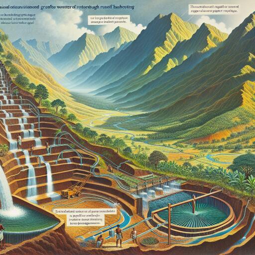
What gets built on the ground
- Contour trenches and earthen bunds: Aligned with contours to slow sheet flow, promote infiltration, and protect topsoil on farmed and degraded slopes.
- Percolation ponds and recharge basins: Shallow, vegetated basins in natural depressions that temporarily hold stormwater and let it seep into aquifers.
- Recharge wells and shafts: Vertical conduits fitted with gravel filters and silt traps, sited along lineaments or permeable zones to inject water below compacted layers.
- Small check dams and gabion weirs: Low-profile barriers across seasonal streams that retain pulses of flow, spread water laterally, and raise local water tables.
- Vegetated filter strips and stone bunds: Edge-of-field measures that reduce silt loads and keep sediment from clogging recharge structures.
Design rules of thumb include safeguarding spillways for cloudbursts, keeping storage ephemeral (days, not months) to avoid mosquito breeding, and scheduling pre-monsoon maintenance for desilting and repairs. Materials are typically local—stone, brushwood, soil—keeping costs and carbon footprints low.
Safeguarding biodiversity and flows
Runoff harvesting in the Ghats must respect the region’s extraordinary biodiversity. That means leaving room for environmental flows, avoiding barriers on fish migration routes, siting away from endemic species habitats, and restoring native vegetation around structures to stabilize banks and create corridors. Sediment management is essential: silt traps and staged basins reduce smothering of downstream habitats. Where recharge could alter wetland hydrology, adaptive operation—opening bypasses during sensitive periods—helps maintain ecological balance.
People-first water management
Community stewardship underpins long-term success. Local councils and farmer groups can help select sites, contribute labor, and oversee upkeep. Benefit-sharing agreements—prioritizing drinking water security and equitable irrigation access—build trust. Training programs on routine maintenance, simple water-quality checks, and pest management keep systems functioning. In many villages, women’s self-help groups have proven effective in monitoring wells and coordinating maintenance budgets, ensuring that governance is inclusive and practical.
From the Ghats to the globe
While tailored to a mountainous rainforest, the approach is versatile. It can be adapted to basaltic plateaus, dryland foothills, and even urban fringes where paved catchments generate sudden runoff. As climate change intensifies rainfall variability, these distributed, nature-based solutions act as low-regret investments: they buffer droughts, shave flood peaks, and help stabilize agricultural yields. By improving infiltration, they can also moderate groundwater temperatures and, in some cases, dilute salinity or pollutants—provided recharge zones are protected from contamination.
A practical roadmap for local agencies
- Compile data: DEMs, land-use maps, soil and geology layers, rainfall intensity grids, and landslide/erosion susceptibility maps.
- Run a multi-criteria analysis to score micro-watersheds for recharge potential and risk, then shortlist sites with community input.
- Ground-truth: Verify soils, depths to bedrock, existing water points, and ecological sensitivities; adjust designs accordingly.
- Build pilots in varied settings (forest edges, agroforestry zones, degraded slopes) to test performance through a monsoon cycle.
- Monitor: Install simple piezometers, use low-cost rain and flow sensors, and track sediment loads; keep a shared dashboard for transparency.
- Iterate: Desilt annually, tweak spillways and trenches, and scale up where data show clear gains without ecological trade-offs.
Financing can blend watershed grants, climate-resilience funds, and community contributions. Aligning projects with soil conservation, rural livelihoods, and biodiversity plans unlocks co-benefits and reduces administrative friction.
Revaluing rain
The Western Ghats remind us that water security doesn’t always require massive dams or deep borewells. With smart maps, small structures, and local stewardship, the monsoon’s brief torrents can be banked underground—quietly, safely, and equitably. Treating runoff as a resource rather than a nuisance reimagines the hydrology of the hills, fortifying communities against dry spells while keeping rivers alive. This is technology serving ecology, and ecology guiding technology—a model for a climate-resilient future.


Leave a Reply