

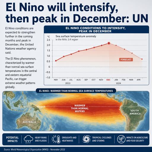
El Nino will intensify, then peak in December: UN
El Niño is gathering strength and is expected to crest in December, according to the United Nations’ weather agency, which cautions that this episode could rank among the most powerful since systematic records began in the mid-20th century. As the event amplifies, it is poised to push global temperatures higher and disrupt rainfall patterns, compounding the influence of human-driven climate change.
A powerful ocean signal with global reach
El Niño arises when sea surface waters in the central and eastern equatorial Pacific warm well above average. That oceanic shift rearranges winds and atmospheric pressure across the tropics, sending ripple effects through the climate system. The result: altered storm tracks, swings between drought and deluge, and a broad tendency toward warmer surface air temperatures. El Niño typically appears every two to seven years, endures for roughly nine to twelve months, and alternates with its cool-phase counterpart, La Niña, with stretches of neutral conditions in between.
Why this one stands out
Global monitoring indicates that sea surface temperature anomalies in the heart of the El Niño region climbed from roughly 1.6°C above average in June to about 2.5°C in August. Projections for October–November–December point to anomalies near 3.7°C above normal—levels that would exceed any previously observed, including the benchmark 2015–2016 event that peaked around 2.6°C.
Consensus guidance from leading national and international meteorological centers shows El Niño intensifying into year’s end, with a near-certainty that it will persist into February 2027. Scientists emphasize that El Niño does not create heat out of thin air; instead, it releases heat already stored in the ocean. With the global ocean running at record warmth, there is more energy available to flow into the atmosphere, boosting the odds of temperature records and extreme weather.
Heat now, hydrological whiplash ahead
As El Niño strengthens, much of the world is expected to see above-average temperatures. Precipitation, however, will not shift uniformly: some regions face an elevated risk of intense rainfall and flooding, while others could be pushed deeper into drought. These contrasts reflect how El Niño reshapes the Walker circulation—altering where tropical thunderstorms cluster and how jet streams steer storms.
Consequences are already emerging. Parts of Central America, for example, are experiencing severe dryness that is stressing crops and livestock. Such early signals are consistent with typical El Niño teleconnections in many tropical and subtropical areas, where water scarcity can intensify rapidly as the event matures.
Timing the peak—and the lag
El Niño usually reaches maximum strength between November and February. However, the largest spike in global surface air temperatures often trails that peak by a few months, as the atmosphere fully responds. The previous El Niño helped drive 2023 to the second-warmest year in the instrumental record and set the stage for 2024 to climb higher still, reaching around 1.55°C above the 1850–1900 pre-industrial baseline.
What to watch in the months ahead
- Marine heat thresholds: Continued warmth across the central and eastern tropical Pacific will be the clearest sign of sustained intensity. Anomalies near or above projected values would reinforce risks of record-breaking warmth on land.
- Rainfall shifts: Anticipate drier-than-average conditions in some parts of the tropics and subtropics and wetter-than-average conditions elsewhere, especially along typical El Niño storm tracks. Local forecasts will refine where the sharpest gradients set up.
- Compounded extremes: As baseline temperatures rise with ongoing climate change, even “typical” El Niño impacts can be amplified—longer heatwaves, more intense wildfire seasons in drought-stricken regions, and heavier downpours where moisture converges.
Readiness and resilience
Authorities, communities, and businesses should prepare for a season of elevated climate volatility. Priority actions include safeguarding water supplies in drought-prone zones, bolstering flood defenses where heavy rainfall is likely, and planning for health impacts from heat, smoke, and vector-borne disease. Farmers and fishers should monitor local advisories closely, as El Niño can reshape growing seasons and marine ecosystems, with implications for yields, prices, and livelihoods.
The bottom line: El Niño is strengthening quickly and is on track to reach its apex in December, with a high likelihood of persisting well into early 2027. In a world already warmed by human activity, the added push from this event raises the stakes for extreme weather and humanitarian impacts. Vigilant monitoring and early action can soften the blow as the planet navigates the months ahead.



Leave a Reply