Evaluating Thermal UAVs for Wildlife Monitoring Efficiency
Thermal infrared drones are reshaping how scientists and conservation teams find, count, and understand wildlife. By sensing heat rather than relying on visible light, Unmanned Aerial Vehicles (UAVs) equipped with thermal cameras can reveal animals that are difficult to observe from the ground, particularly in low light or partially obscured habitats. The result: faster surveys, richer datasets, and fewer disturbances to the species being studied.
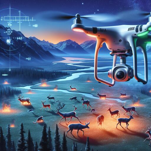
Why thermal matters
Traditional monitoring often hinges on daylight visibility, baiting, or lengthy foot surveys. Thermal imaging instead detects the heat signatures of animals, enabling safer, quieter, and more discreet observation. This is especially useful for nocturnal and cryptic species, and for landscapes where visibility is poor. While dense canopies can still obscure targets, temperature contrasts often allow detection through gaps in vegetation or along edges and clearings.
Key gains include:
- Higher detection rates for elusive species in low-light conditions
- Reduced human presence in sensitive habitats
- Broader coverage in less time, improving survey efficiency
- Consistent data across seasons and times of day
Field performance compared to traditional methods
Across open grasslands, wetlands, and mixed forests, thermal UAV surveys typically shorten field time and increase detection accuracy relative to ground-based counts. In open terrain, wide-area transects from low to moderate altitude can identify individual animals and herd boundaries with clear thermal contrast. In more complex habitats, pairing slower, lower flights with careful flight planning improves detection along trails, riparian corridors, and canopy gaps.
Beyond simple presence/absence, thermal video enables fine-scale behavior insights—movement patterns, group cohesion, and habitat preferences—without the bias introduced by human observers on foot. Repeated flights standardize observation effort, supporting robust trend analyses for population monitoring.
Cost, access, and scalability
Declining hardware costs and off-the-shelf platforms have made thermal UAV monitoring increasingly attainable for conservation groups, universities, and local agencies. Compared with large-scale ground surveys, drones can reduce travel, staffing, and logistical overhead, especially in remote or rugged landscapes. For programs with limited resources, the ability to conduct shorter, targeted flights on demand can be transformative, enabling more frequent data collection and rapid response to emerging conservation needs.
Minimizing disturbance and improving ethics
Non-invasive observation is a central advantage. Well-planned flights at appropriate altitudes and times of day minimize stress, reduce noise exposure, and keep field teams out of sensitive areas. Because the technology records heat signatures rather than identifiable details, thermal imaging also supports privacy-minded monitoring in human-wildlife interface zones.
Adaptability across ecosystems
From mangroves to savannas, thermal-equipped UAVs adapt to a wide range of conditions. In wetlands, thermal contrast often distinguishes animals from cooler water surfaces at dawn or dusk. In forests, mixed strategies—combining thermal with visible or multispectral imagery—can improve detection and habitat mapping. In open rangelands, higher-altitude transects can quickly delineate population distributions and movement corridors.
Conservation applications
- Population assessments: More accurate counts for management and recovery plans
- Protected area design: Identifying activity hotspots to inform boundaries and zoning
- Human-wildlife conflict mitigation: Locating animals near farms or roads to guide rapid response
- Anti-poaching and patrol support: Nighttime detection and route optimization
- Rescue and translocation: Fast localization of at-risk individuals in fires, floods, or droughts
Practical considerations and limitations
Despite clear advantages, success depends on careful planning and technical know-how:
- Sensor and altitude trade-offs: Resolution and field of view determine detection range and flight height.
- Environmental factors: Wind, humidity, and surface heating can mask thermal signatures; crepuscular flights often yield better contrast.
- False positives: Warm rocks, machinery, or livestock can appear animal-like; machine learning and ground truthing help reduce errors.
- Data management: Thermal video generates large datasets requiring efficient storage, labeling, and analysis pipelines.
- Compliance and safety: Adherence to airspace rules, wildlife permits, and ethical guidelines is essential.
Where the technology is heading
Advances in onboard processing and AI are accelerating detection and classification directly in the field, reducing the time from flight to decision. Multi-sensor fusion—thermal plus RGB, multispectral, or LiDAR—promises richer habitat-context data and improved species discrimination. Standardized protocols for flight planning, metadata, and validation are also emerging, making results more comparable across projects and regions.
A pragmatic path forward
Thermal UAVs are not a universal solution, but they are a powerful, scalable complement to traditional methods. Programs that define clear objectives, select appropriate sensors, and invest in pilot training and data workflows consistently report gains in efficiency and data quality. When combined with community engagement, regulatory compliance, and transparent ethics, the approach supports conservation that is both evidence-driven and minimally invasive.
As biodiversity faces growing pressures from habitat loss and climate disruptions, the ability to monitor wildlife accurately—and to act quickly on those insights—matters more than ever. Thermal UAVs offer a practical, field-ready way to expand our view of the living world while leaving a lighter footprint on it.


Leave a Reply