

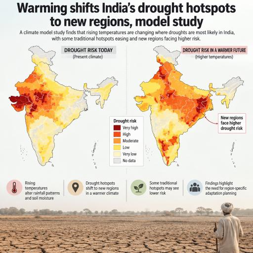
Warming shifts India’s drought hotspots to new regions, model study
Climate change could redraw India’s drought map, bringing greater water stress to agricultural regions that have not traditionally been considered highly drought-prone. New modelling suggests that parts of central, eastern and northern India may face some of the sharpest increases in drought hazard as global temperatures rise.
The assessment examined India’s 15 agro-climatic zones under global warming of 2°C, 3°C and 4°C above pre-industrial temperatures. Compared with conditions during 1995–2014, about 56% of the country’s land area moved into a higher drought-risk category at 2°C of warming. The share was 47% at 3°C and increased to 60% at 4°C.
The most severe hazard category, which covered only 0.17% of India in the historical reference period, expanded to nearly 11% under the 4°C warming case.
Drought risk moves beyond India’s dry west
India’s western drylands and parts of Gujarat already experience substantial drought exposure. However, the projections indicate that future changes will not simply deepen existing patterns. New hotspots could emerge across the Central Plateau and Hills, the Eastern Plateau and the Upper Gangetic Plain.
The Central Plateau recorded the most pronounced change in median drought hazard. Areas previously placed in moderate categories rose into high or very high categories under 4°C of warming. The Middle and Lower Gangetic Plains also shifted upward, raising concerns for densely populated farming regions where water systems have developed around relatively dependable seasonal supplies.
This geographical movement has important implications for adaptation. Irrigation capacity, groundwater management, crop selection and drought-response programmes based mainly on historical experience may fail to protect newly exposed districts.
Heat can worsen drought even when rainfall rises
The analysis combined three features of drought: frequency, duration and intensity. It used an indicator that accounts for both precipitation and potential evapotranspiration—the amount of water that could be transferred from soils and plants into the atmosphere under prevailing weather conditions.
This approach captures a crucial effect of global warming. Higher temperatures increase the atmosphere’s demand for moisture, so soils and vegetation can dry more quickly even where rainfall remains stable or increases.
Indeed, the model projected higher average annual precipitation across India at all three warming levels. The national climatic water balance also improved on an annual basis. Yet these gains were distributed unevenly throughout the year and across the country. Additional rainfall during wetter periods may not compensate for stronger evaporation and reduced moisture availability during critical planting or growing seasons.
Dry-season pressure intensifies
The timing of drought change varied with the degree of warming. At 2°C, the largest nationwide increase in hazard occurred before the summer monsoon. Under 3°C, the strongest rise shifted to the post-monsoon period. At 4°C, winter drying became more pronounced, with the national winter water balance falling by about 26.6 millimetres.
Changes during the southwest monsoon were comparatively small and, in the hottest scenario, the national hazard indicator declined slightly for that season. This contrast shows why annual rainfall totals alone can give an incomplete picture of future water security.
A wetter monsoon could still coexist with damaging dry spells before or after the rains. Such seasonal disruption could affect sowing dates, crop development, reservoir operations and groundwater recharge. More intense rainfall may also run off rapidly rather than replenishing soils and aquifers.
Mountain regions face added stress
The Himalayas remain vulnerable because high-elevation areas can warm faster than lowlands. Rapid temperature increases raise potential evapotranspiration and can widen moisture deficits, even in places that receive considerable rain or snow.
Coarse-resolution climate models cannot fully represent the steep terrain and highly localized weather of the Himalayas or Western Ghats. Nevertheless, the results highlight how temperature-driven water loss can create drought risk in regions that might not appear threatened when judged by rainfall alone.
Projections come with uncertainty
The findings should be treated as an indication of possible trends rather than a precise forecast for individual districts. The drought assessment relied on one climate model selected for its ability to reproduce historical rainfall variability and the broad behaviour of the Indian summer monsoon.
Historical checks produced mixed results. The model represented drought duration and intensity more reliably than drought frequency or the combined hazard score. Other uncertainties include the equal weighting assigned to drought characteristics and the model’s limited ability to capture local conditions at a resolution of roughly 0.25 degrees.
The warming thresholds were also associated with different emissions pathways and time periods. In the modelling framework, 2°C was reached around mid-century under an intermediate pathway, 3°C later under a higher-emissions trajectory, and 4°C toward the end of the century under very high emissions. The lowest-emissions pathway did not cross these thresholds before 2100.
Planning for a changing drought map
Despite its limitations, the assessment provides a warning for water and agricultural policy: India’s future drought burden may expand into regions with limited preparation for persistent moisture stress.
Adaptation efforts will need to extend beyond historically arid areas. Priorities could include more efficient irrigation, stronger groundwater monitoring, drought-tolerant crops, improved soil-moisture conservation and seasonal warning systems. Planning must also account for when water shortages occur, not only how much rain falls over an entire year.
The central message is that warming may reorganize drought exposure rather than merely intensify dryness in familiar hotspots. Preparing central, eastern and Gangetic agricultural zones for that shift could become essential to protecting food production and rural livelihoods.



Leave a Reply