Assessing disaster resilience in mountain villages using an improved DPSIR-A framework and multi-model machine learning
As extreme weather intensifies and mountain slopes destabilize, the question facing many high-altitude villages is not just how to recover from crises, but how to endure them. A new assessment approach tailored to tourism-based ethnic communities in rugged terrain combines social and ecological indicators with machine learning to map where resilience is strong—and where it falters.
An upgraded lens on resilience: DPSIR plus Adaptability
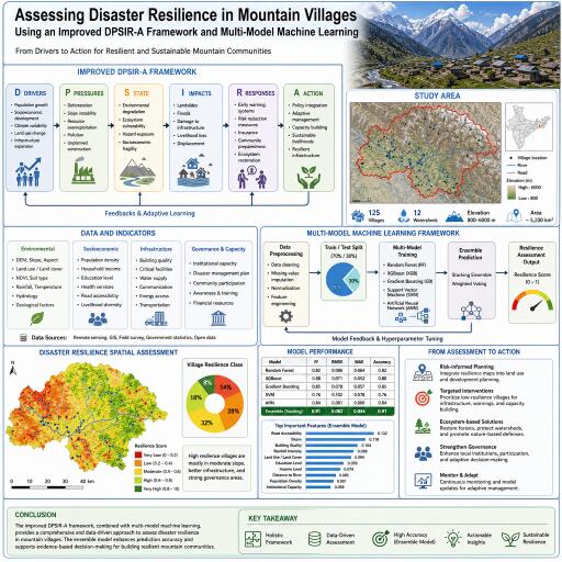
The study refines the widely used DPSIR framework—Drivers, Pressures, State, Impact, Response—by adding a crucial sixth dimension: Adaptability. This Adaptability component captures community learning and traditional ecological knowledge, recognizing that local experience, cultural practices, and informal networks often determine whether a village can anticipate hazards, adjust behavior, and rebound quickly. In mountain tourism hubs where livelihoods hinge on both ecological quality and visitor flows, this broader lens helps reveal the subtle interplay between nature, economy, and culture.
Solving the small-data problem with smarter models
Mountain hazard datasets are typically sparse and skewed, with far fewer examples of low-resilience cases. To correct this imbalance, the researchers combined SMOTE (a synthetic oversampling technique) with a sequence of models—IVM, SVM, and Random Forest. This multi-model chain leverages complementary strengths: generalization from limited samples, non-linear separation, and robust variable importance. The SMOTE-enhanced Random Forest ultimately led the pack, indicating that class-balancing can be a decisive step when data are scarce.
What the numbers say
- Model breakthrough: The SMOTE-boosted Random Forest delivered the best results, with AUC = 0.753 and Kappa = 0.754. It was notably sharper at flagging low-resilience zones, a persistent blind spot when classes are imbalanced. The gains suggest that synthetic minority examples help models detect marginal communities that would otherwise be overlooked.
- Spatial patterning: In Zhangzha Town, resilience is shaped by “topography-constrained economic clustering.” A compact high-resilience core (13.05%) is centered on the Ganhaizi area, anchored by stronger socio-economic adaptability. In contrast, an extremely low-resilience belt (9.42%) is dispersed along the southern edge, where steep slopes, access challenges, and slower response capacity undermine preparedness.
- Nonlinear drivers: Fractional Vegetation Cover, rainfall, and distance to roads emerged as dominant predictors. Beyond physical exposure, “soft” capacities—building disaster resistance and villagers’ disaster awareness—significantly moderated risk, underscoring that social investment can offset some environmental disadvantages.
Why this matters for mountain communities
By uniting ecological indicators with social readiness and access infrastructure, the DPSIR-A approach moves beyond hazard mapping to resilience mapping. That shift is vital for planning in tourism-reliant villages where a single disrupted road can isolate entire neighborhoods and where vegetation loss can cascade into landslides, water scarcity, and lost income. Identifying where adaptability is weakest enables targeted training, safer construction, and strategic investments in connectivity that protect both lives and livelihoods.
Method insights and transparency
The model chain—IVM, SVM, Random Forest—allows cross-checking results and ranking factors by importance, helping decision-makers see which levers matter most. SMOTE addresses class imbalance without inflating false positives excessively, improving recognition of hard-to-detect low-resilience pockets. The analysis highlights nonlinear responses common in mountainous terrain: small changes in vegetation or rainfall thresholds can rapidly shift risk profiles, while road proximity can be the tipping point between timely evacuation and dangerous delays.
Policy takeaways and practical steps
- Strengthen “soft” resilience: Expand disaster-awareness programs, drills, and early-warning literacy; incentivize building reinforcement and retrofits tailored to local hazards.
- Protect and restore vegetation: Prioritize slope-stabilizing plant cover and watershed management to reduce landslide susceptibility and buffer intense rainfall.
- Secure access lifelines: Maintain and diversify evacuation routes, improve all-weather road standards, and ensure critical facilities sit within rapid-reach corridors.
- Target high-risk clusters: Use resilience maps to direct funds, equipment, and training to the southern periphery of Zhangzha Town and similar steep, response-lagging zones.
- Align tourism and safety: Manage visitor flows, enforce construction codes for guesthouses, and integrate hazard signage and evacuation planning into scenic areas.
- Back community learning: Support local knowledge exchange platforms and culturally grounded adaptation practices that amplify the Adaptability dimension.
Looking ahead
This resilience blueprint—fusing DPSIR-A with class-balanced, multi-model machine learning—offers a practical template for other mountain regions facing converging climate and geohazard pressures. Its strength lies in exposing where ecological fragility, infrastructure gaps, and social capacity interact, converting scattered data into clear priorities. As climate extremes intensify, the payoff will come from scaling such approaches: improving local data quality, updating models after major events, and embedding community-led learning so that every training, retrofit, and reforestation effort compounds over time. In high places where margins are thin, that compounding may be the difference between enduring the next disaster—and being defined by it.


Leave a Reply